EXISTING CONSTRAINTS
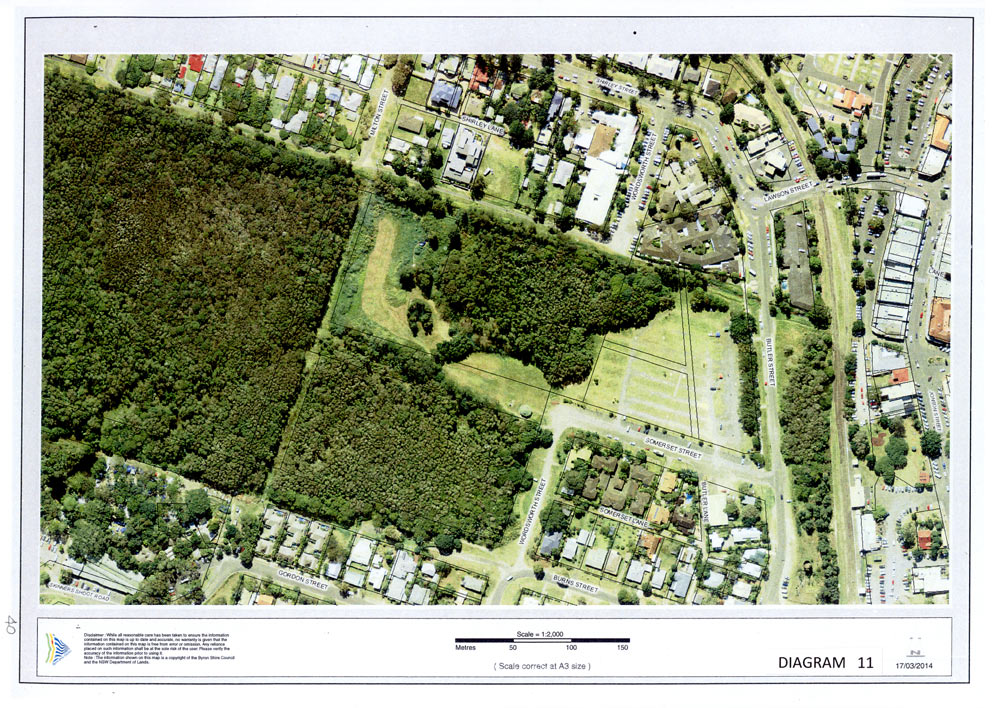
The area shown in photo diagram No 11 extends from Railway Park to the western Cumbebin wetlands and from Shirley Street to Burns Street in the south. This location has vast areas of natural vegetation which are critical to the biodiversity of the western town area but also facilitate efficient stormwater management and environmental sustainability. The eastern section is partly degraded by mine tailings remaining from past activities and the cleared area now used for regular markets. Butler Street is the primary connection of this area to the outside world and fulfils many functions from a local residential traffic collector road to a major access and car park during markets and other activities and as a controversial town bypass to reduce future traffic congestion through the town centre.
The markets are an essential part of the Byron culture and symbolise much of the town as well as providing an essential outlet for the trading of locally made products from the many artisans and talented people who live here. The Thursday farmers market supplies much of the town and allows local producers to be selfsupporting. It is important to retain the local identity of goods and people in the major Sunday markets and not to allow outside interests to infiltrate.
The stormwater drainage from the town drains through the open creek along the northern site area before progressing through the wetlands to Belongil creek and then to the ocean outlet at Belongil beach. The overall process of natural filtering and purification of this water is essential to the survival of the mangroves and species in Belongil creek and ultimately the health and stability of marine life and the ocean.
POTENTIAL
The potential to upgrade this precinct is to satisfy both active and passive needs and keep the area in balance by:-
- extending shade trees through the market area
- upgrading the market facility
- providing adequate parking
- facilitating traffic movements
- providing direct pedestrian connections to the town centre
- maintaining the connection between residential and open space
- rehabilitating the wetland
enhancing the biodiversity within the wetlands and its extended environmental areas
- preserving the wetland, creek and ocean environments
- facilitating stormwater storage, filtration and discharge through natural channels
- using stormwater with natural treatment for grey water reuse in the town centre
- providing nature trails and eco walks through the wetlands for enjoyment and education
- maintaining the green buffer zone between Butler Street and the town
- providing a new aged care community facility on the existing hospital site when it becomes redundant.
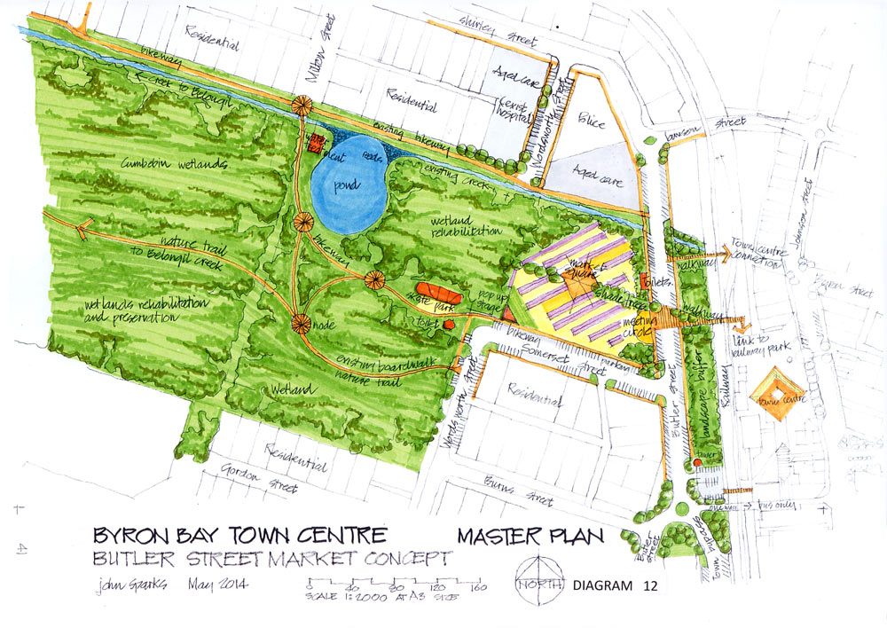
DESIGN CONCEPT
The eastern end of this concept outlined in diagram No 12 is the activity area where the markets are held and is closely connected to the town centre.
An alternative layout for the market stalls is shown as a suggestion only to the current configurationwhich works well.
The market area can be upgraded by extending the trees from the western side through the centre of the markets to link with the landscape buffer along the western side of the railway tracks. This would provide shade and shelter which would be welcomed by stallholders and customers andcomplement the existing shaded tree frontage to Butler Street.
Another suggestion is a market square to act as a focus for group activities and give a sense of arrival as well as a pop-up stage to give better facilities for performers in the south western corner.
New toilets along the Butler Street frontage and a meeting circle for visitors and drummers would formalise the activities in this area.
Pedestrian walkways from the market to the town centre are important to directly link these twoareas and connections are shown to Byron and Jonson Street shops as well as Railway park past the north end of the existing station platform.
Car parking is always an issue on market days and many additional spaces are provided with angle parking along both sides of this section of Butler Street. This would also provide long term parking during the week for workers and visitors so that spaces within the centre could be replaced by additional circulation space for people and landscaping.
The multiple pedestrian access points and flow between the town centre buildings and the open park space is a logical connection for residents and visitors and will expand the horizons and experience of the town.
This concept also provides an important connection from the wetlands to the landscaped buffer along Butler Street, to the landscaped areas in Railway Park and into the street planting which expresses the natural feeling of the town.
At the south end of Butler Street a roundabout is shown to separate through traffic and the residential areas along Butler Street. This would allow a one-way bus only access to the new transit centre located at the south end of Railway Park, as mentioned previously, and would also feed into a new town bypass road located directly next to the existing railway line reservation.
This bypass would also provide additional parking with direct pedestrian access to Jonson Street, have much less impact on the natural environment and completely separate the residential precinct west of Butler Street from the busy town activities with a landscaped buffer zone.
Details of this bypass are provided later in the overall master plan. From the active eastern end of the Butler Street markets we proceed to the wetlands of the Cumbebin Swamp National Park to the west.
The area immediately west of the markets is an old tailings site left over from sand mining operations and is in need of rehabilitation to restore the natural balance and biodiversity of the national park.
The existing open creek along the north side of this precinct drains the town stormwater from around Byron Street to discharge through the swamp to Belongil Creek and subsequently to the ocean.
A pond is provided in this area to assist with the rehabilitation works which provides additional flood storage capacity as well as being a natural filter for the water flow with reed beds and other plants to provide filtration.
This pond could also be used as part of the town grey water reticulation system with final treatment and pumping back to the town for toilet flushing, cleaning and landscaping.
The pond would enhance the natural environment for the adjoining residential area and would be accessible from the existing bikeway and the new bikeways and nature trails through the swamp.
The nature trails could extend from the existing boardwalk off Wordsworth Street to Belongil Creek and connect through to Milton Street as an extension of the existing bikeway.
These trails have focal points of natural interest along the way which all adds to the experience and enjoyment of our unique environment for locals and visitors alike.
ESSENTIAL COMPONENTS
The real value of this precinct is to enhance the active eastern market section and rehabilitate the passive western area to give value to the biodiversity and access for all to learn and enjoy.
There are many options for market layouts, parking and pathway locations but the principles in this concept that should not be compromised are to:-
- upgrade the market facilities
- provide a row of shade trees through the market to connect the natural wetland and town landscaping
- retain the landscape buffer between Butler Street and the railway line
- provide additional walkway connections between Butler Street and the town centre
- upgrade Butler Street to supply additional parking
- provide a new town bypass road away from the Butler Street residential area
- provide the one way bus only access road to the Railway Park transit centre
- rehabilitate the wetland west of the market area
- connect the wetland and open space to the Cumbebin Swamp National Park
- provide a water management and treatment pond to the existing creek stormwater drainage
- provide nature trails and boardwalks to experience the wetlands and connect with the town bikeways.