An outline of the PLANNING STRUCTURE OF THE BYRON MASTER PLAN
TOWN STRUCTURE
When we live in or visit any town or city we essentially move, occupy, enjoy and experience this place from the open space between buildings or major geographical features.
This open space around the built environment can vary from a large planned area for communal activities to a small leftover space between buildings or a street or path which leads us into another space.
These streets and laneways are the arteries and the spaces are the organs which allow the town to give life and interact with the people who choose to come and experience this place.
The importance and significance of these open spaces is the basis of this study which essentially looks at the public domain - the space outside the buildings.
The unique quality of these spaces is that they are not buildings - they are open spaces where people meet, gather, play, enjoy or just sit and watch.
We will look at the activities within and around these spaces where people may eventually proceed into the buildings if they are interesting, inviting and enjoyable to their experience.
These open spaces already exist, in some cases they are exciting and enjoyable while in others they are degraded or abused but they all have the potential to fulfil many community functions and aspirations through our motivation and incentive to activate them.
This can happen as we honour and respect nature and give meaning to each area which will range from the practical and active use to the passive enjoyment of the immediate environment.
The overall structure of Byron Bay town centre is defined by four major open spaces.
These four spaces, their connections with each other, and their extensive natural assets encourage different activities but they are all important to allow the total experience of Byron.
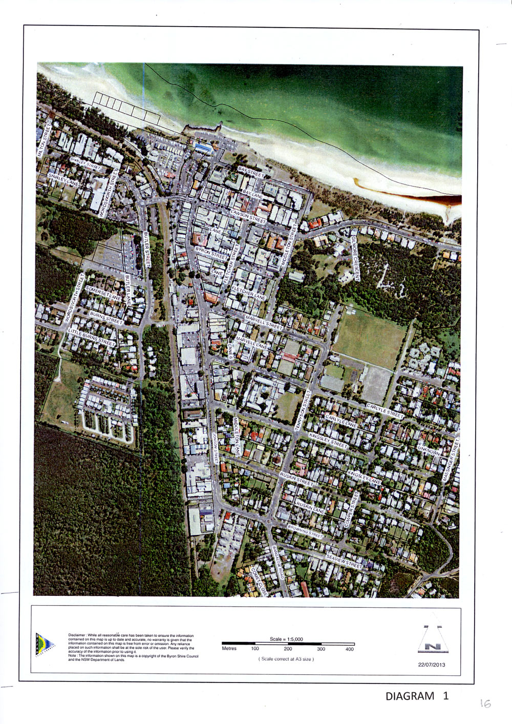
From the photo diagram No 1 we recognise these areas mostly by the green planting that remains, some from intentional landscaping, and others from the natural wetlands and connections to the beach environment.
The open areas are located throughout the town, in the north at Apex or Beach Park including Main beach and Clarkes beach, to the south is Railway park and the station, in the east is the area from the Library to Tallow beach and to the west is the Butler Street reserve extending to the Cumbebin wetlands.
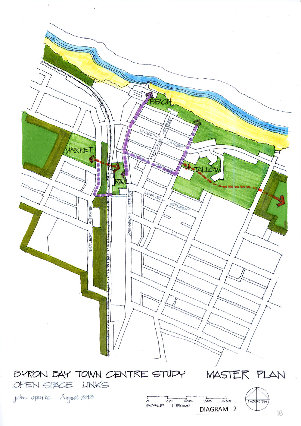
For simplicity these spaces will be referred to in this study as Beach, Tallow, Rail and Market. These spaces all have a character that is both individually unique yet collectively significant. They are outlined on the plan diagram No 2 which shows the extensive green areas around and through the town with their links to each other.
Each space generates a theme based on their general use and location, their connections and potential activities and uses which would enhance the overall functioning of the town. The general feelings, activities and potential these spaces evoke are listed in diagram No 3 and there are no doubt many others that could be added.
BEACH
Beach park connects directly with the vast north facing beaches extending from Clarkes beach through Main beach and Belongil and eventually to Brunswick Heads.
The sea environment extends through a unique protected marine reserve to Julian Rocks and contains many reefs with their abundance of sea creatures and marine life. Beach is fun, the open sea, distant views, the vastness of nature, the pristine ocean, the different moods of the powerful, turbulent, stormy and calm sea, the movement of the tides, the ever changing beach, the refreshing water, the waves, the whales and dolphins, the wreck, Julian Rocks, the coral reefs and abundant sea life, to swim, sunbake, surf, relax and play on the beach, the drummers, the patterns on the sand, kids playing, music and art, sunsets over the hinterland and sunrise over the headland, the moon, the clouds, the sun, the seasons, canoes, snorkelling, scuba diving, kites and para-surfing, sunshine and lighthouses all in the open cradle of nature’s caldera under the watchful eye of Wollumbin. To walk through the town and open to the expansive panorama of the beach is a must do experience for Byron town.
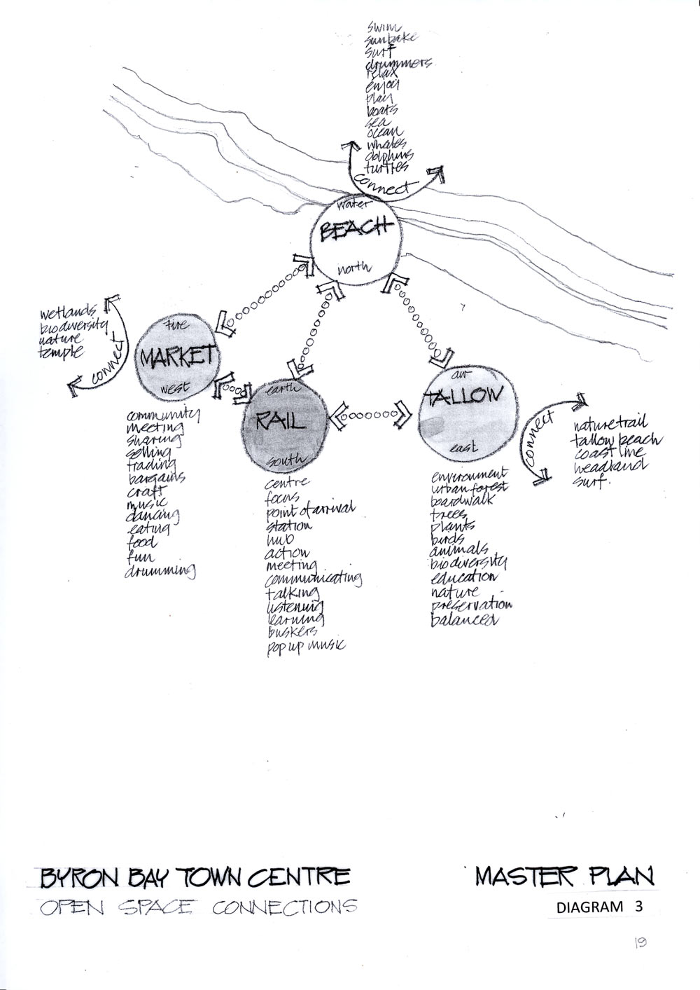
TALLOW (Library to Tallow)
Tallow is a more intimate area mainly accessed from Middleton Street and connecting through extensive wetland, coastal heath and national park, to the east facing Tallow beach. The area closest to the town centre contains the library, Courthouse, child care centre and youth activities centre giving an immediate community focus. This space then extends to Tallow beach through a natural environment. Tallow suggests community, a meeting place, connection, local forums interaction, natural environment, biodiversity, regeneration, enjoying nature, environmental education, learning, house gardens, permaculture, growing food, treating waste, a balance between community and nature. The preservation of this area has the potential to become a significant focus for visitors to absorb, learn and enjoy as well as contributing to the social wellbeing of residents.
RAILWAY
Railway Park is an active space in the centre of town, it is a point of arrival and departure for many visitors, it is the central focus for public meetings, social interaction, the town square, the link with the Community Centre, a place for buskers and entertainment, a transport hub and interchange from bus to rail, local to interstate, private and public, a place of continual movement and a transition zone between the outside world and the township.
MARKET
The Butler Street reserve west of Railway Park is the market centre where the weekly farmers market and regular craft markets are held as well as other outdoor community meetings and entertainment. It is for buying and selling, eating and enjoying, entertainment, trading, bargains, music, dancing, meetings friends, drumming and is fully accessible without disrupting the general flow within the town. Market is an ideal venue for outdoor pursuits and is part of the environmental area that extends to the west through the Cumbebin wetlands to Belongil creek. These areas are environmentally significant, although in need of rehabilitation immediately to the west of Butler Street reserve and are part of the natural stormwater drainage from the town to the creek. These areas also have potential for restoration, treating stormwater before discharging to Belongil Creek and are a significant natural buffer zone around the township to preserve and enhance its village character.
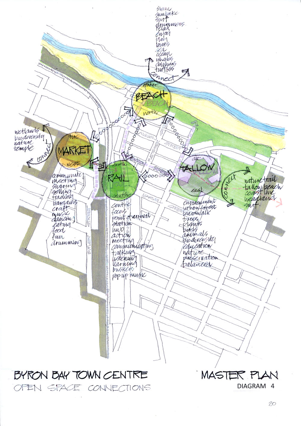
These thoughts are superimposed on the town map in diagram No 4 together with their internal links and external connections to show the importance of the interactions between these individual spaces and how they establish the functional framework and structure of the town centre. Each of these spaces is now assessed within its immediate context showing the existing constraints, and putting forward some ideas which provide a concept to realise the full potential of the areas within the aims and ideals outlined previously.